The Lao group consists of about 25 islands surrounded by reefs. Entering through passes in the reef to access the interior of the lagoon can be “easy to very difficult” depending on the island, number of passes, tides, winds, current, lagoon size, etc…
The Lao Group (both Northern and Southern) are in very remote areas and far away from the tourist track. However, they have become a very popular cruiser destination. There is good fishing, great diving, rich cultural experiences, and beautiful scenery.
The Fijians in this region follow a subsistence lifestyle not greatly different than their ancestors. There are rarely different races in the outer islands. In addition, land is rarely changes ownership from its original indigenous ownership.
The outer island life is very simple, and the people are poor in material terms, but rich in so many others. Most villages have a small store, but it is rarely full and often empty waiting for the supply ship (which comes once per month). There is no wifi in the Southern Lau and very little wifi in the Northern Lao.
This group of islands differs from the Tuamotus in French Polynesia in that they typically have islands inside the reef. In the Tuamotus, they had islands on the reef and rarely inhabited islands in the center.
Lau Group Tour
Wayne wanted to see the outer islands in the Lau Group which spread across hundreds of miles. Unfortunately, our sail plan is dictated by the weather which typically has winds from SE. Making going East or SE very challenging.
As you know, we picked up Wayne in Vanua Levu, Savusavu. After spending a few days here, we got a light weather window to make a short passage. So, we took him NE to Taveuni. It was a short passage of about 40-45nm.
We picked up a mooring at the Paradise Taveuni Resort and went ashore to enjoy sunset by the pool. They allow cruisers to come enjoy the resort services including the beautiful, negative edge pool.

The sunset took our breath away. Here are some photos of the sunset lighting up the anchorage.

Then the colors shifted and created a rainbow of colors in the sky.

Matt got a little artsy behind a bench and the effect is fabulous.

We stayed here two nights and allowed Wayne to get his sea legs. But it was time to leave as the weather was perfect to make a bee line for the Southern Lao Group.
Southern Lao Group
Ideally, we would have sailed to the Northern Lao Group, then slowly make our way down south. This is a much easier jump off point to Kadavu, then Viti Levu the island where we will drop him off. But the weather would not allow this sail plan. So, we will make a figure 8. We will sail South, then back up North, then back down South, then west. Sound like fun?
Our trip from Taveuni to Ogea is about 165nm and is an overnight passage. We left around 0800 from Taveuni and enjoyed a nice and easy sail for the first 5 hours! Then fish on! The boys had 3 lines out and a teaser line. As luck would have it, the largest lure caught the fish. We all rushed to bring in the other 3 lines, slowed the boat down (we were doing 8-9kts and had to slow it down to 2-3kts). Wayne started bringing in the fish, but tired after 20 minutes of fighting with the beast. Matt took over for 10-12 minutes, then handed the reel back to Wayne.
He brought in a 60kilo, 1.5-meter yellow fin tuna! He was a fighter!

Before he took his last breath, he gave Wayne one more present…a leg full of pee (see upper right photo). He was a beast and will feed many, many people!

The boys have some fun with Charlie before he was cleaned.

It took 3 of us, 3 hours to clean and stow this bad boy. He filled up our 40liter Engle freezer!
Trip Details (Taveuni to Ogea)
Our next destination was Southern Lao Group, specifically Ogea.
- Total Miles: 165nm
- Passage Time: 24 hours (hook to hook)
- Max Speed: 11.2kt
- Average Speed: 6.8kt
Ogea (pronounced Ongea)
Ogea is a rather large island with a few places to anchor. We found a super beautiful, albeit shallow bay and had it all to ourselves for most of the day. Our friends on Scooter came in and anchored later that afternoon.
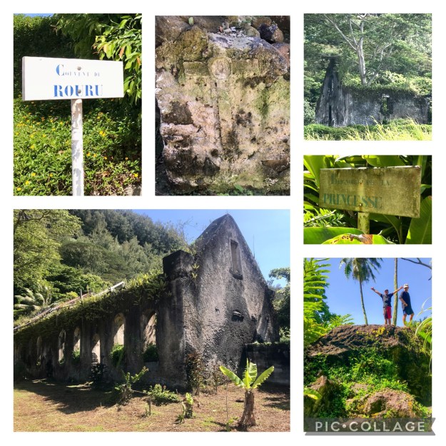
The next morning, we all made the hike to the village to do our sevusevu (offering to the chief in exchange for permission to anchor in his waters and visit his village). The place to catch the path to the village is tricky to find. Lucky for us we had a way point and found it behind a large rock. The tide varies about 1.5m each day so we came in at high tide and returned to very low tide.

The path is a mixture of rocks and dirt. Lots of critters around to entertain us. The Ogea village has about 80 people currently living there. We came during low tide and the town was flooded. Some of the water came up and over the ill built sea wall, but the majority of it came up through the ground which was limestone. It was so unfortunate as most houses sit slightly over the water, but the path to and from the houses are across 1-6” of water.

This is a photo taken after church as villagers were making their way back home.
Our host, Lolo invited us to church, which is obligatory, so we accepted. We donned our sulus (like sarongs) and headed to church. The drums (upper right corner) are played 15 minutes prior to church and then 5 minutes prior.

The primary school is absolutely lovely! They have math equations on each side of a cement water well (bottom right), and beautiful words on each pillar (upper right). They teach this at a young age which is truly why Fijians are such friendly, generous, and kind people.

The Chief
Usually the chief’s are fairly welcoming and happy to see cruisers as we come with gifts. However, this chief seemed rather perturbed that we were interrupting his carving and even “barked/yelled” at a little girl making her cry. Not sure what was going on, maybe just an “off day.” None the less, our headman “too ranga nee koro” proceeded with the short ceremony, presented our kava and gift of tuna, and welcomed us into the village. The chief is the master carver of the village and even his tikis are a little grumpy.

Carvings from the Chief
Our host, Lolo then took us around the village, showing us the church, the school, and the path to a different anchorage. We ended up walking across many dry lands which are typically covered in 1m of water. Global warming is taking its toll in Fiji!

Exploring Ogea
We act a wee bit goofy holding up rocks.

On the way back, another local named “Mess” was kind enough to give us each a coconut. This was well received as it was super-hot and a long walk back to the dinghy (45-minute hike). As you can see the tide went out again so the dinghy was grounded. Luckily we took Scooter’s dinghy which is a lot lighter than our girl Sweetie.

On our last night, we decided to do a beach BBQ with Scooter (Thomas and Marieke). Matt grilled some tuna, and Thomas prepared some tasty potatoes. Super pretty views.

Beach BBQ
Ogea Lovo
After Sunday service, our host family put on a lovo and provided a massive feast for us. We were so surprised by the amount of food!

Lovo with our Host Family
Tons of food, fish, taro and cassava (starch like potatoes), noodles, and more.

A super friendly cat kept us entertained.

The top photo is our host with our group and the bottom photo is Humberto who has become an official Fijian.

An excellent way to end our time in Ogea! Tomorrow we head to Yagasa.
Yagasa (pronounced Yangasa)
Yagasa is an uninhabited island in the Lao Group frequently visited by locals from neighboring islands for fishing. There is no way to go to shore unless you have rock climbing gear and know how to repel up the cliff. There is a Boobie bird colony on the towering hillside by our anchorage.
But the anchorage is peaceful, calm, and beautiful. The birds sing to us periodically, and make great bird watching.

Lakeba (pronounced Lakemba)
Lakeba is the “capitol” island of the Lao group. We did not stop in the main village because the pass is precarious at best. Instead we anchored in a small “indent” in the reef. At first, I thought it would not be very protected, but as it turned out we had a lovely evening at the base of an enormous, lush and well populated bird mountainside.

We thought we were being stealth by coming here with the hopes of getting internet. We were able to get internet two different times when we sailed past the island. However, our lovely mountainside blocked the signal and we had zero connectivity while anchored here. Good thing we were only here for one night.
Stay tuned for Part II of our Figure 8 tour around the Lao group.
Events from this blog occurred in the first two weeks of July. Our blog posts run 8-10 weeks behind actual events. In our last blog, we take Wayne on a tour of Savusavu.