Tag Archives: hike

Great Barrier Island

We are free!!!  Oh my goodness after almost 3 months in the marina we finally break ourselves free to do some sailing around New Zealand.  We’ve been tied to the dock doing boat projects and meeting with different vendors and have not had a moment to go sailing until now.  We decide to head to Great Barrier island first and if time and weather permits, Mercury Island.

It is a slow motor down the Whangarei River.  We request permission to have the Te Matau a Pohe “Hook Bridge” open so we may pass under.  Still an amazing thing to see!

It is a beautiful day, albeit light wind on the nose.  We raise the main sail and continue on a motor sail as we don’t even have enough wind for the jib.  We pass by the Hen and Chickens Islands.  I just love their names.

Kaikoura Potato Bay

We approached Great Barrier Island and made the last minute decision to go to Smokehouse Bay which is supposed to be a nice boatie/cruiser bay.  However, when we approached we saw that there were close to 30 boats anchored there – so we stopped short and anchored in Kaikoura Bay also known as Potato Bay.  We had this beautiful bay all to ourselves.

We were expecting some ugly winds so we moved the following morning to a new bay.

Wairahi Bay

There were still a lot of boats at Smokehouse Bay so we decided to go to a bay just past it (still in Great Barrier Island).  We arrived to Wairahi Bay with 3 other boats.  Perfect!  From here we can easily visit the other bays within the western side of Great Barrier Island. We hang out in this anchorage for over  a week.  Several other boats joined us in this anchorage, but it is big enough to not feel crowded.

First, we explore the river that feeds into Wairahi Bay.  Matt took the SUP up the river during high and low tide so that he felt comfortable taking the dinghy with me.  It is so cool to be surrounded by hillsides, overhanging trees, and hidden houses. 

I spotted at least 5 hidden “baches” (summer houses) in the trees.

Smokehouse Bay

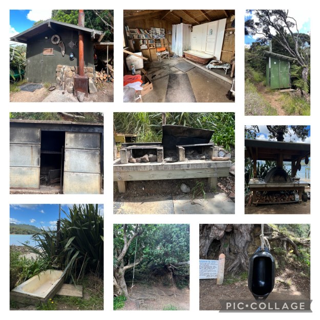
About 1 mile down from our anchorage is a popular spot called Smokehouse Bay.  It is a place created for locals and cruisers/boaties.  This as the anchorage that was incredibly busy when we first arrived. However, the weather changed which made this a very uncomfortable anchorage so everyone cleared out when we visited.  This is a shot during low tide (top) and high tide (bottom).

The facilities in this bay were provided by the late Eric Webster and his many friends.  Locals and cruisers maintain the property and equipment.  The Weber family placed Smokehouse Bay under the protection of the Queen National Trust as an open space covenant for the public whilst remaining in private ownership.

A massive rain storm destroyed Smokehouse Bay in November 2005.  Everything was covered in mud and debris and it took over a year to rebuild the facilities.

What can you enjoy at Smokehouse Bay?

  • Pizza Oven
  • Smokehouse (perfect for smoking fresh catch)
  • Grills
  • Laundry hand crank basins and clothes lines
  • (2) showers including 1 that offers hot water from a wood burning stove
  • Free book trade library
  • Toilets
  • Outdoor seating area around a bonfire
  • Great hikes on the 5 hectres (50 acres)

We enjoyed the entire bay to ourselves because it was inclement weather and all the boats left for a more protected anchorage.  We hiked to the summit and had excellent views of the bay.

Port Fitzroy

The most populated bay in Great Barrier Island is Port Fitzroy.  It is where you can get fuel and some supplies.  Super cute little town with a market, library, visitor center, and burger joint.  The town is the top photo.

There are two great hikes in this bay.  One starts from the center of town and leads you to a beautiful waterfall and the other is across the bay and leads you to a spectacular crows-nest view.

We decide to do the waterfall hike first, since we were already in town and it is only a 40minute hike to the falls.  But it is straight up.   First, you clean your shoes with a spray and scrub…then off you go down the path.

About 40-minutes, 300+ stairs, and 1.5 miles  later we arrive at the triple waterfall.

We take a moment to enjoy the beauty around us, dip our toes in (its freezing), and head back.

Next we take our dinghy across the bay and leave it at the dock (red arrow).  We then hike to the valley (green arrow on right), up to the peak and back down to the dock.  Super good hike.

At the top of the peak is a swing bridge that leads you to a 600-year old Kauri tree.  Once at the tree, you can climb up to the crows-nest to get a spectacular view of the bay.

As we make our way back down the hill we take a turn off to Sunset Rock.  I bet this would be wonderful to watch the sunset…

All in all we hiked 10.5 kilometers or 6.5 miles.  We were a bit bushed when we got back to the boat.

Historic Floods

We ended up spending a little more time in Great Barrier due to bad weather.  Lucky for us we were tucked away in the perfect anchorage for inclement weather.  Evidently this is a once in 50 year flood and yet it happened twice within a week!

Everything was flooded including the airport, grocery stores, and busses!

And of course the streets and highways.

We weather the second storm at a different bay called Karaka Bay at Great Barrier.   This was the calm before the storm.

Some more beautiful photos from Karaka Bay

I just love the stunning motus, rock formations, and islands.

Our friends captured us heading up the river, n our way back to the marina.

Events from this blog occurred in late January 2023.  Our blog posts run 6-8 weeks behind actual events.  Don’t miss our last blog where we explore the Lost Springs.

Exploring Mana Island

While waiting for our mail sail t be repaired, we decide to head to Mana Island, a small island about 10nm to the west of the mainland of Viti Levu.   We stopped by this little island while my sister, Kimberly and her family were visiting, but we wanted to come back to explore some more.

Mana Island has a small airport and is home to the 2nd oldest resort in the Mamanucas, Mana Island Resort.  This resort is owned by the Chinese who built a rather ugly fence down the middle of the island to separate its leased property from the backpacker resorts.

Mana is also where Survivor: Game Changers was filmed and we were determined to find its location.  So, it seems an exploratory hike is in order.

Hiking Around Mana Island

The Plan: find the Survivor set (which is on Maps.me), the bunker, and the cross.  It shouldn’t be too hard, just a little adventuring.  We should have brought the garmin to determine how far we truly walked and to show you the entire path, but we forgot it.  I did not think to turn on my maps.me app until we were half way through our hike, so I will walk you through our path.

Sugar Shack is at the blue arrow. We take the dinghy to the beach (left side of island, below “South Beach.”  We walk along the beautiful beach during low tide which gives us access around the entire bottom tip of the island (the yellow on the map indicates the beach area and the green is hillside).  

Once on the windward side (right side of island), we head up hill (start of the light blue dots) and make our way to through a very exclusive, 5-star resort, called Tadrai Dream Resort.  Oops, we weren’t supposed to be here.  However, the staff let us wander through the back of the small 5 villa resort to the top of the hill where the cross is located.  From here we walk the ridge to the bunker, then down to what is supposed to be the Survivor set.  Through the 4-star Mana Resort and back to the beach where we started.

Beach Walk

The start of our walk was super pretty along several long sandy beaches.  The hillsides are dry as we are on the dry side of Fiji, but the beaches are beautiful with untouched sands. 

Once we round the tip of Mana Island, we encounter beautiful purple rocks scattered around the beach.  I just love the beautiful art nature created on these rocks.

We reach the end of the beach where a giant cliff prevents us from continuing on (top left picture) so we turn left up the hill.  We get to a small road.  To the left is heli-pad (lower right corner) and to the right is the very exclusive, 5-star resort Tadrai Dream.  We did not know it was a 5-star resort until we got back to the village.  But it sure did look pretty with a negative edge pool and its 5 villas (yep, only 5 villas).

The trail is a combination of a dirt path and tree limbs lined up to make stairs.

The top of the hill rewarded us with beautiful views.  I did not take any photos of the cross as it was less than pretty.  Sugar Shack is the white dot in the dark blue water to the right.

We can see on either side of the island: the anchorage and the windward side.

Bunker and Survivor Set

We continue on to the bunker which is just along the ridge line.  It appears there was a controlled burn here and a very old antenna.  Can you see the bunker in the top photo (see the burn area and then a white box)?

As we continue along the path we head back down hill to the “Survivor” camp which is what Mana is famous for.  However, we circle, and circle, and circle and come up with the big donut hole.  However, we did find a large rectangle field that was cut out from the shrubbery.  Perhaps the “challenges” were held here.  But the actual spot where it says “Fiji Survivor Set” is nothing but leaves on the ground.

Well that was a bit disappointing – not sure what we expected to find, but nothing was not it.  Not even an immunity charm!

We continued on and ended up at the Mana Resort (another “exclusive” place) and we just walked right in all smelly and dirty from our hike.  They did not seem to mind and let us continue on.

We ended the walk at the village where we saw the most fruitful papaya tree – it had 7 growing branches!

Overall a great exploration of Mana Island.  We managed to walk around half the island which is about 4.2 miles. 

The events from this blog occurred in early September 2022.  Our blog posts run 6-8 weeks behind actual events.  Our main sail explodes in our last blog, Tired and Work Out.

Mo’orea Hike to Point Taraieie

After 32 days of confinement we were finally free!  We were allowed to explore, hike, and ride bikes around Mo’orea.  It has been months since Matt and I had exercised our legs on a good hike.  On our first day of freedom, we set out on 6.7 mile hike straight up 85 stories (almost 1,000’).  Our goal is to get to the ridge at Taraieie.

It started out easy enough along a paved road, then behind one of the two local markets.  The paved road turned to a nicely manicured dirt road sandwiched between beautiful private gardens. 

About 2 miles into our journey it started to rain.  Not a torrential rain shower, but it was enough to force us into hiding for 30 minutes.  Now our beautiful trail turned muddy and very slippery over the fallen leaves and tree roots. Gots to be careful in our flip flops (yes, stupid I know).

Matt has always been stronger when it comes to a hike.  He is literally like a goat climbing a hill.  He spent most of the hike looking for me and waiting. 

Along the way we found lots of fruit trees.  The soursop fruit which is really lovely (sort of like a berry and apple flavor) grows right out of the tree branch which sure looks funny to me.

Many beautiful flowers bloomed in the shade of the tall trees.  These particular bird of paradise flowers had a beautiful iridescent glow to them when the sun spotlighted them.

We made it to the top with relatively no drama.  It was a beautiful view of Vaiare Bay.

The way down was a bit of a challenge for me.  I kept slipping out of my flips, crashed on my arse a few times, and felt the aches and pains of someone who has not being hiking in a while.  But a hike is a hike as long as you complete it – and complete it I did!

It was a great day to be out moving. But I will admit I was pretty tired by the time we got home.

We get down and dirty cleaning and repairing the boat in our last blog.  Coming up next, we rent eBikes to circumnavigate around the entire island of Mo’orea.

Events from this blog post occurred during the third week of August, 2021.  Our blog posts run 10-12 weeks behind our adventures.