Tag Archives: coco beach

Mo’orea Escapades

Many cruising friends are anchored near us during our stay in Opunohu Bay, Mo’orea.  We have Steve and Lili on “Liward,” Josh and Rachel on “Agape,” Octavia and Peter on “Bella Marina” and a few others. Which makes it so much fun to explore.

Mystique Magic Mountain

Believe it or not, Magic Mountain Mo’orea has its own Facebook page!  Its peak is more than 300 meters high located in Papetoai.  It is private property owned by a local family.  They charge a mere 200 francs ($2) to enter their property and make the steep incline up the path.

There are two paths to the summit.  The path to the left is longer, but not as steep.  The path to the right is faster, but much steeper. Once at the top of the summit you are rewarded with a 360-degree view of Baie De Opunohu.

The family has a small eatery at the entrance to Magic Mountain where they will sell you tourist stuff, cold beverages, food, and more.  Makes for a nice stop at the end of your hike.

Steve, Lili, Octavia, Matt and I set off conquer the mountain. Lower right photo has the boys pointing to the top of the summit (so does the middle left photo with the blue arrow).

Magic Mountain Hike

Magic Mountain Hike

There is a decent cement path that leads up the mountain (we took the shorter, super steep path).  It is more frequently used by the ATV tours and 4×4 tours.  Every once in awhile you get a tourist taking a rental car up which is more than amusing to watch.

There are several view points where you can rest on a super uncomfortable, solid, concrete benches.

The views at the summit are gorgeous.  To the right is the anchorage in Opunohu Bay.

To the left is the Tiki anchorage.

The summit

Summit at Magic Mountain

Summit at Magic Mountain

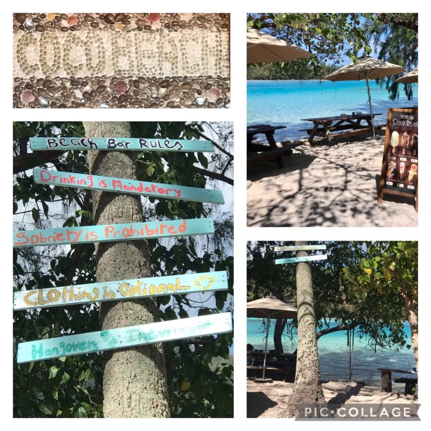
Coco Beach for Lunch

We decide to take a long lunch by heading to Coco Beach.  You might check out our previous post on Coco Beach for fabulous photos.  Steve, Lili, Josh, Matt and I get a table by the water and under a shady tree.  Such a great time with pitchers of Mojitos and tasty food.

Side Trip to Tahiti

My friend Krista needed to go to Tahiti to get her PCR test done. I decide to tag along because “why not?”  We meet at the ferry dock and arrive in Tahiti around 0900 in the morning.  We had so much fun stopping by the artisan markets, local tourist stores, and Papeete Market.  I take her to pick out her own pearl to add to the collection of pearls she bought from me.  We then head to a jewelry store where they drill her 4 pearls, sell her the black line to make her a bracelet and necklace and then assemble the pieces for her.  She walked out of the store with two pretty pieces of jewelry for a total of $16 (that included the price of the pearls, drilling the pearls, and all the pieces to make the jewelry).

We head back on the ferry and hitch hike back to Opunohu Bay.  The great thing about Mo’orea is that the locals are super generous with lifts.  They will stop, pick you up and deliver you where you need to go with a smile on their face.  For no money, just the pleasure of helping you out.

Pretty Sunset Photo – Mo’orea

I go on a tour in search of the humpback whales in our last blog..  Events from this blog post occurred early October.  Our blog posts run 10-12 weeks behind our adventures.

Coco Beach: Mo’orea

We needed a beach day to decompress from all of our activities.  But a beach day for the Konis family is anything but relaxing on a beach.  Love them!  We head to Coco Beach which is located on a small motu called Tiahura just off of Mo’orea.

The restaurant is located on a heavenly islet. Hidden in the trees and on the sand are dozens and dozens of tables and benches. You rest your toes in the sand as you enjoy their tasty morsels.  Service can be a little slow but not surprising when you see the dozens of tables.  Right as you enter the eatery you are met with a very humorous sign.

We take every opportunity we can for photo ops:

Sisters, the very best of friends.

The Konis’s and Mitchell’s

Of course, there was loads of volleyball

An amazing lunch to go along with the bevy of cocktails

And loads of swimming to cool off from the hot sun. I love the shameless branding photo with Cole.

In our next blog we explore an underwater tiki garden, a juice factory, and introduce my family to some of our cruiser friends.  In our last blog the boys learned how to foil and we did a transparent kayak tour. – check it out.

Events from this blog post occurred during the first week of August, 2021.  Our blog posts run 10-12 weeks behind our adventures.

Dushi Island

As we explored the island we kept seeing a lot of stores, signs, and shirts with “dushi” on it – “Dushi Dive” “Dushi Bonaire” and all sorts of other “Dushi” things.  How weird.  In America, “Dush” is a derogatory word.  So, I had to ask the lady a local what “dushi” meant and to my surprise she said it was a term of endearment, meaning “sweet/sweetheart.”  Well now that makes a lot more sense!  Still, I do not think I can bring myself to buying a shirt, hat or trinket with “dushi” written on it – or can I?


Bonaire is a quiet, charming, and pretty clean island with about 19,000 inhabitants.  The government has determined that they will only grow to the size of 30-35k inhabitants.  Bonaire is part of the Netherland’s Antilles, with its sister Islands, Curacao and Aruba.  Other Antillean islands include St. Maarten, Saba, and Statia.  They capital Kralendijk (pronounced crawlen dike) which is the main port and the only mooring area.  The entire island is only 12 square miles and the inhabitants only occupy about 5% of the island. Another 25% of the island is the National Park.  The two main industries are salt and tourism even though they do not really cater to boaters.

Being the third best dive spot in the world makes diving a huge part of their tourism business, but they also have a booming business in snorkeling, windsurfing, and bird watching.  In addition, you can enjoy parrot, donkey, and flamingo sanctuaries.  Windsurfing takes place on Lac Bay, a large lagoon on the windward side of the island which is protected from seas by a low lying reef.  The depth is only about 1 meter and it is 2 miles from shore to the reef which makes a large protected area for beginners to learn how to windsurf.  Professional windsurfers run the windsurfing school called Jibe City. Bonaire is home to the top 4 windsurfers in the world so you can learn from the best!.

Jibe City Windsurfing School

Jibe City Windsurfing School

There is only one stop light on island and it is not used for traffic.  It actually says STOP FOR PIZZA.  Love it.

Stop For Pizza

Stop For Pizza

There are 12 massive windmills on the North Eastern side of the island and they each provide 1 megawatt of energy.  The island however, uses about 22 megawatts of energy so they built a plant which can generate up to 24 megawatts of energy during the time the windmills cease to provide their share (September-October).

A tour is definitely in order to help us get the lay of the land so to speak.  It appears that most of the site seeing places require a car so we might have to look into that as well.  Places of interest include Washington Slagbaai National Park, parrot sanctuary, donkey sanctuary, Rincon, Salt Flats, Cave tour, Cadushi Factory, Blow Hole, Salt Flats,  Famingo Sanctuary, Slave Houses, Seru Largu, Lighthouse and ruin and the dive sites including 1,000 steps, pink beach, Klein Bonaire, and more.

Currency is the U.S. dollar even though it is a Dutch island.  I believe some places still take the guilder (sometimes called the florin) which is about 1.78N to the $1. We used guilder while we were in St. Maarten a few times.

The main languages in Bonaire are Dutch, English, Spanish, and Papiamentu which is a mix of languages that started with the slaves who did not understand, Dutch, English, or Spanish.  A small glossary of words can be found here.

Bonaire is really flat, dry and full of cactus which is very different from the Caribbean islands we are used to which are filled with mountains and lush terrain.  Most people think that Bonaire is a volcanic island but we learned it is really a tectonic island (meaning the plates in the ocean push up the island over time).  But to me, when you look at the island it looks like a choral island as it is filled with choral everywhere.