We found a FAD (fish aggregating device) on the windward side of Puaumu. In my last blog, I shared how we repurposed several elements of the beacon that was attached to the FAD. Today, I am going to share with you what we did with the entire FAD raft. We did not feel comfortable leaving the FAD on the shores of the island. So, we disassembled the FAD with a razor-sharp knife and a few hours of our time.

Fish Aggregating Device
The FAD was built using 8 pieces of bamboo, heavy netting, 8 floats, and lots of various line (rope) holding it all together. We started our work during low tide so we had more room to work on the raft which was about 2.5 meters x 2.5 meters. After we cut the lines, we removed the netting, and separated the bamboo and floats. Our friends on Moira (Ruby and Thomas) helped us with the removal.

Fish Aggregating Device
Moving the FAD to the Other Side of the Island
Then the “fun” began as we tried to lug all of the pieces across the island to the leeward side (where our local friend’s Stephan and Manu have a camp. We were not sure what we were going to do with all the pieces, but we knew it could not stay on the windward side (Pacific Ocean side). The netting was ridiculously heavy as it was soaking wet and covered in barnacles. The bamboo sticks were also holding water – we tried everything we could think of but the darn things would not drain! We strung a long line through the floats and just dragged them to the other side and tossed all the small cut lines into a large piece of netting to carry over.
Matt gave it some thought and came up with a grand idea to recycle the FAD pieces.
Relaxation Station
We decided to make a love seat aka “relaxation station” near Stephan and Manu’s camp. Because why not? We picked a nice shady spot facing the ocean and began the “design phase”. Trying to figure out which bamboo pieces needed to be cut (using a saw), which needed to stay long, and which needed to be the support.

Design Phase
There was a bit of trial and error but it was slowly coming together. Matt started working on the netting, once the bamboo was in place. This was tricky as we had to make the netting really tight to hold multiple guests. The problem with that was that the line we had was soaked and sunbaked which made it weak. The netting tore easily with the slightest bit of pressure. Hmmmmm…

Matt was determined to only use pieces taken from the FAD on this relaxation station. He did not want to use any of our sturdier line or netting which made the construction that much harder. He finally figured it out after several not so successful attempts.

Of course, Matt and I had to test it out. It was still wet and had some barnacles that would not leave the net, but other than that – not bad!

Events from this blog post occurred during the last week of April, 2021. Our blog posts run 10-12 weeks behind our adventures.


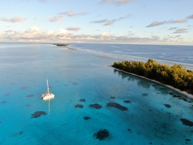
 This photo gives you an idea of how very isolated we are when we visit this small piece of paradise. This shot looks at the far left (North West) corner of Puaumu.