Tag Archives: pacific

Minerva Reef

Minerva Reef is a natural phenomenon and a true wonder of the world.  Located 800nm from New Zealand, 250nm from Tonga, and 450nm from Fiji – it is situated in the middle of the Pacific Ocean.  Minerva Reef is made up of the South atoll and the North atoll.  During high tide both reefs disappear giving you the illusion of being anchored in the middle of the Pacific Ocean.

Many cruisers make it a priority to stop at one of the two reefs as they traverse between New Zealand, Fiji, and Tonga. Very few people can claim that they’ve made this stop so it is a huge honor to experience it.

Minerva Reef was named after the whaler Minerva which was wrecked in 1829 on South Minerva reef.  Unfortunately, the reef has claimed many shipwreck victims over the years.  One famous wreck in 1962 called Tuaikapeau was even turned into a documentary depicting the victim’s survival on the reef for over three months. 

These two atolls have been the center of much dispute between Tonga and Fiji.  Both of whom have laid claim to the reef.  As of now, Tonga claims ownership even though no living souls inhabit the land.  Makes sense as the reef (or land) disappears every 12 hours during high tide.

Geography of Minerva

Minerva Reef is a limestone base made of uplifted coral formations on the top of a dormant volcano.  During high tide, only a few pieces of the reef are visible.  During low tide, much of the reef is clearly visible forming a figure 8 (south) and a circle (north).

South Minerva

Coming from New Zealand we approach South Minerva first.  This atoll looks like two circular rings interconnected like a figure eight. 

The west circle is only accessible by dinghy (see red arrow).  We explore a bit here then head back before low low tide.  The water is spectacular.  

When we arrived, there was one boat here.  By the end of the day 2 more boats arrived. But this is a huge lagoon and we were spread apart.  The next morning the 3 boats left and we were alone in this beautiful location.

The lagoon has crystal clear blue water.  However, the anchorage is pretty deep 18-30m which makes it hard to see the bottom.   The diameter of this atoll is about 4.8km.  We can clearly see the reef all around us during low tide.

We take Sweetie out to explore the reef.  Even though we are hundreds of miles from the very cold NZ, I sill find myself shivering and did not want to get in the water.  But we did take the dinghy all the way up to the reef and managed a great look around.

We find one of the two lights on South Minerva, although she is not working any longer.

North Minerva

North Minerva reef is almost a complete circle.  On the NW corner there is a pass that allows vessels to enter the lagoon.  This reef is about 6.8km in diameter and is a little more popular than its sister in the south.  This pass and lagoon are easier to navigate and more pleasant to anchor in.

Another wreck occurred here on this atoll called the wreck of the Comonderry which is now a good snorkeling site.  This was a steel ship which had a colorful history before she ran aground in 1969.

We snorkel around the bow and stern and find tons of wildlife in and around the sunken ship parts and pieces.

A beautiful sunset to make you smile.

Our blog posts run 10-12 weeks behind live events.  We visited North and South Minerva around mid-July.  If you are wondering how we got here, please read “Voyage: New Zealand to Minerva.”

In our last blog we shared our voyage from NZ to Minerva – did you read about those adventures?

The Beauty of Puaumu

The beauty of Puaumu takes my breath away.  We had this beautiful motu all to ourselves for well over a week where we simply enjoyed nature.  The waters have so many different shades of blue that you could create your own blue rainbow.  

Puaumu is located in the north east corner of the Gambier Archipelago.  Two local families own this motu which makes it private.  On occasion, locals will come out here for the weekend and enjoy the beautiful setting. Cruisers tend not to come this far north because it is not charted, but it is still navigable.  Below you can see where the charts end…white space.

The windward side, facing the Pacific, looks like it has a sandy shore.  However, that is not the case.  Dark rocks and coral line the tree line and the shore line is covered in light rocks and coral.  Sugar Shack in the background.

Puaumu is a medium sized motu.  It is about .4nm in length and .1nm in width at the widest part.  The center of the island is covered in a palm trees and a variety of lush green trees.  The windward side is covered in coral and rocks making it a challenge traverse across.  The leeward side is a small sandy beach home to tons of hermit crabs and other sea/land-based critters.  Many coral heads liter the lagoon side of the island making it a challenge to navigate to a safe anchorage.

Puaumu Lagoon

Puaumu Lagoon

Puaumu Highlights

Matt caught the sun lighting up the tree tops at sunrise.  The shades of blue in the lagoon start out turquoise and slowly blend in to a beautiful hue of purple.

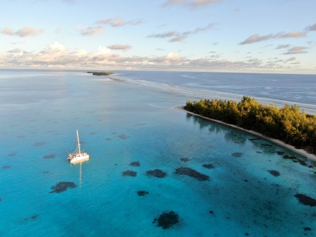
This photo gives you an idea of how very isolated we are when we visit this small piece of paradise.  This shot looks at the far left (North West) corner of Puaumu.

Love this reflection of Sugar Shack in the water.

Check out our reflection

Check out our reflection

Looks like the sun is our anchor light on steroids.

A few more stunning photos

Sunrise at Puaumu

Sunrise at Puaumu

Moonrise at Puaumu

Moonrise at Puaumu

Love this photo of the sun reflecting off of our dagger board.

The American Flag never looked so good.  Made of Sunbrella – thank you ManuKea.com for the awesome flag that lasts forever and still looks beautiful!

Port Sugar Scoop / Transom – just a wee bit proud of our home!

Just a beautiful sunset with colorful rays in the sky.

Check out our other post on Puaumu.

Because of low bandwidth we had to spread our posts out. Events from this blog post occurred during early April 2021.  Our blog posts run 8-10 weeks behind our adventures.

Robinson Crusoe and Easter Island

Live Blog: Traversing the Pacific

We interrupt this program for a live message (for those of you old enough to remember when they said that on TV).  Matt and I are starting a long passage across the Pacific Ocean. We will suspend our normal, narrative blogs while we live blog.  We will resume the narrative blogs around mid-April.

Our journey will start today, from Valdivia, Chile.

It will take us 4-5 days to make it to Robinson Crusoe island.  We hope to see how the original Robinson Crusoe (Alexander Selkirk) entertained himself for four years on a deserted island.

After a day or two of rest, we will head to Easter island, also known as Isla Pasqua and Rapa Nui.  This passage should take us 2-2.5 weeks.

Hopefully we will get 3-4 days to recover and explore the Moai before setting sail for Pitcarin Island.  We may or may not stop here, depends on the weather and protection of the anchorage.  This passage should take us 8-9 days.

After Pitcarin, we will make our way to Mangareva, Gambier (first archipelago of French Polynesia).  We hope to arrive here by mid-April.

The map shows Santiago.  Valdivia is south by 500nm miles.  You will then see Robinson Crusoe and Rapa Nui.  The other islands are off the charts.

Robinson Crusoe and Easter Island

Robinson Crusoe and Easter Island

The Pacific is a huge ocean and can be both beautiful and inspiring while also fraught with danger.  We hold a great deal of respect for the Pacific and will take all pre-cautionary measures to ensure our safety and the safety of the boat.

The “live blogs” use a satellite service, so we are not actually online.  We won’t be able to see any comments until we get back to wifi.  However, our blog will automatically post to the Sugar Shack Facebook Page so be sure to follow that to get updates. (Christine’s personal FB page will not be updated)

If you want to track our progress across the Pacific, you can click on “Current Location” tab on our blog svSugarShack.com.